Image 1 of 4
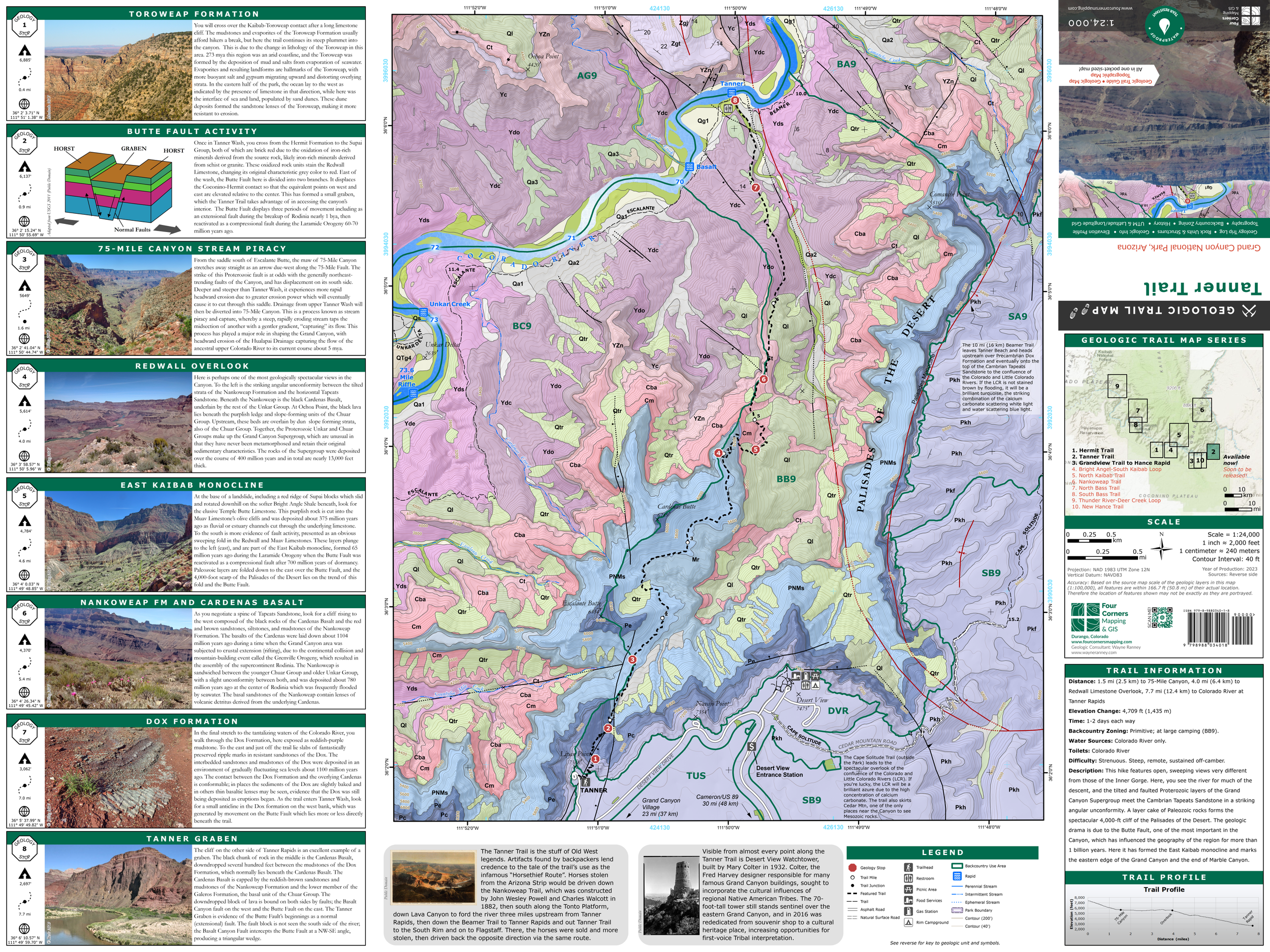 Image 2 of 4
 Image 3 of 4
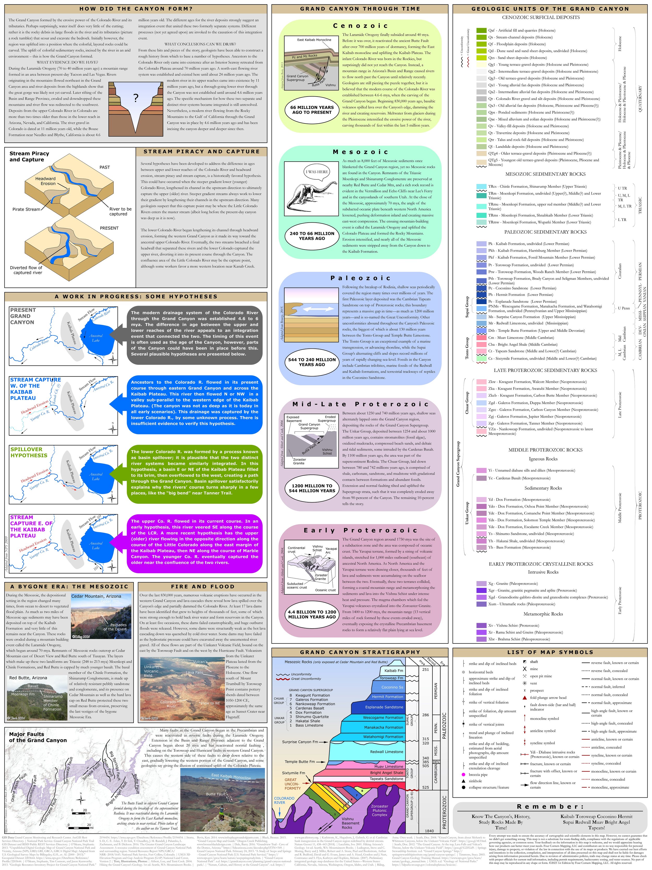 Image 4 of 4
These folded pocket-sized maps are waterproof and tear-resistant and are also available as georeferenced digital maps on the Avenza Maps store.
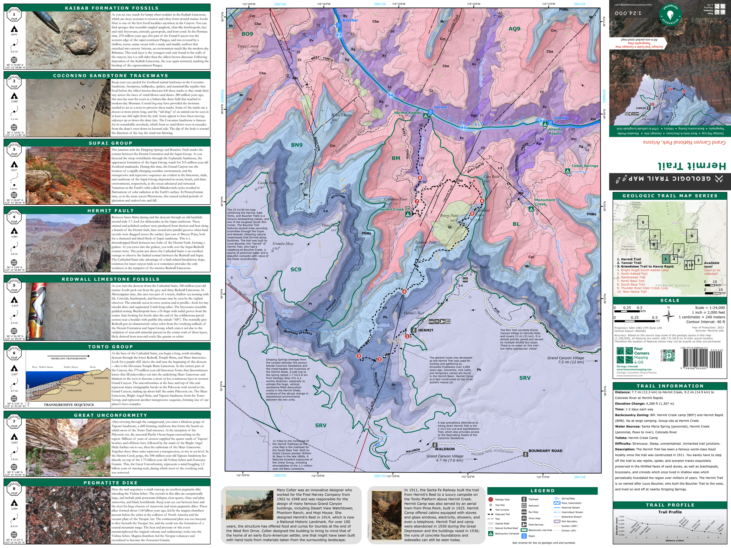
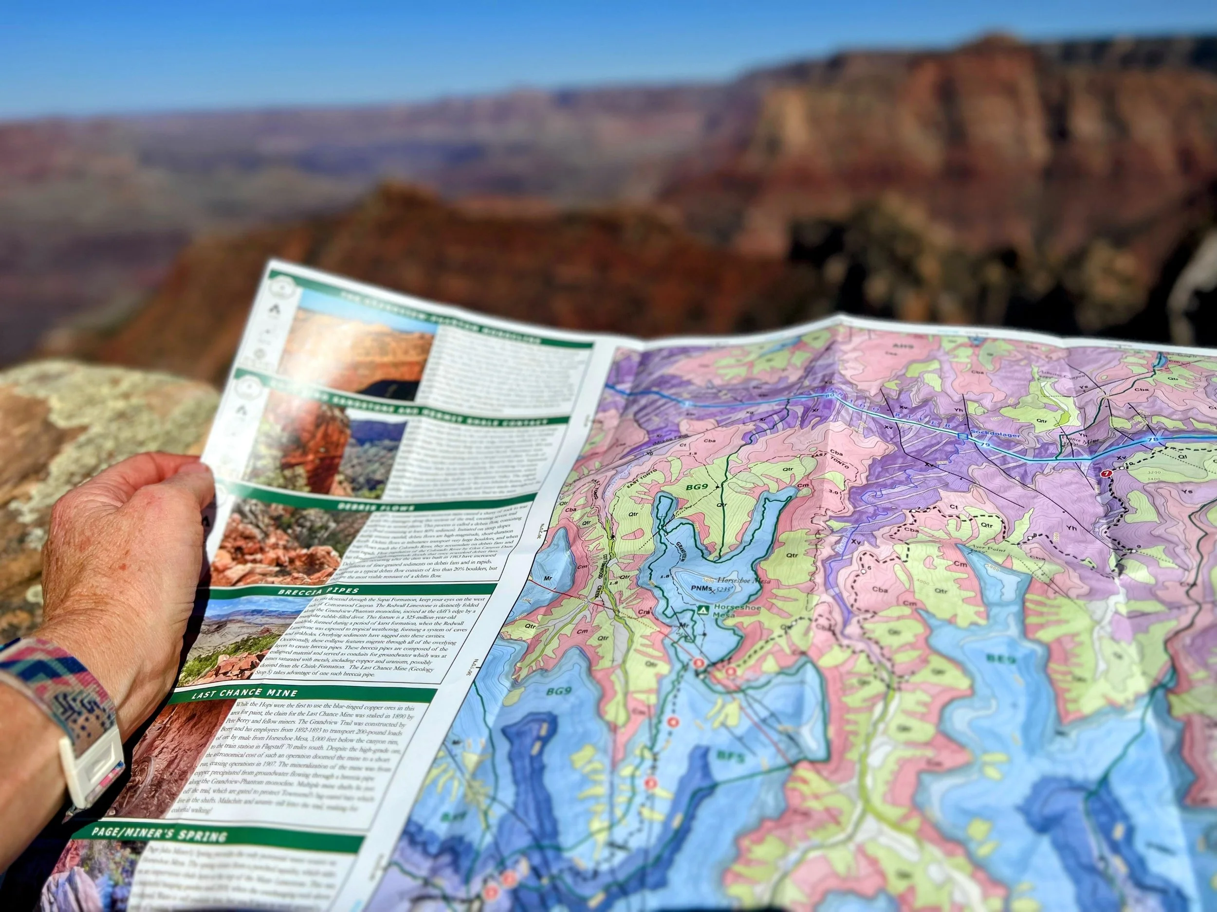
The Geologic Trail Maps of the Grand Canyon combine the best of two worlds: geology and hiking! Part geologic guidebook, part topographic trail map, the rich geologic content provides a succinct geologic summary of the trail without the need to bring a heavy guidebook.
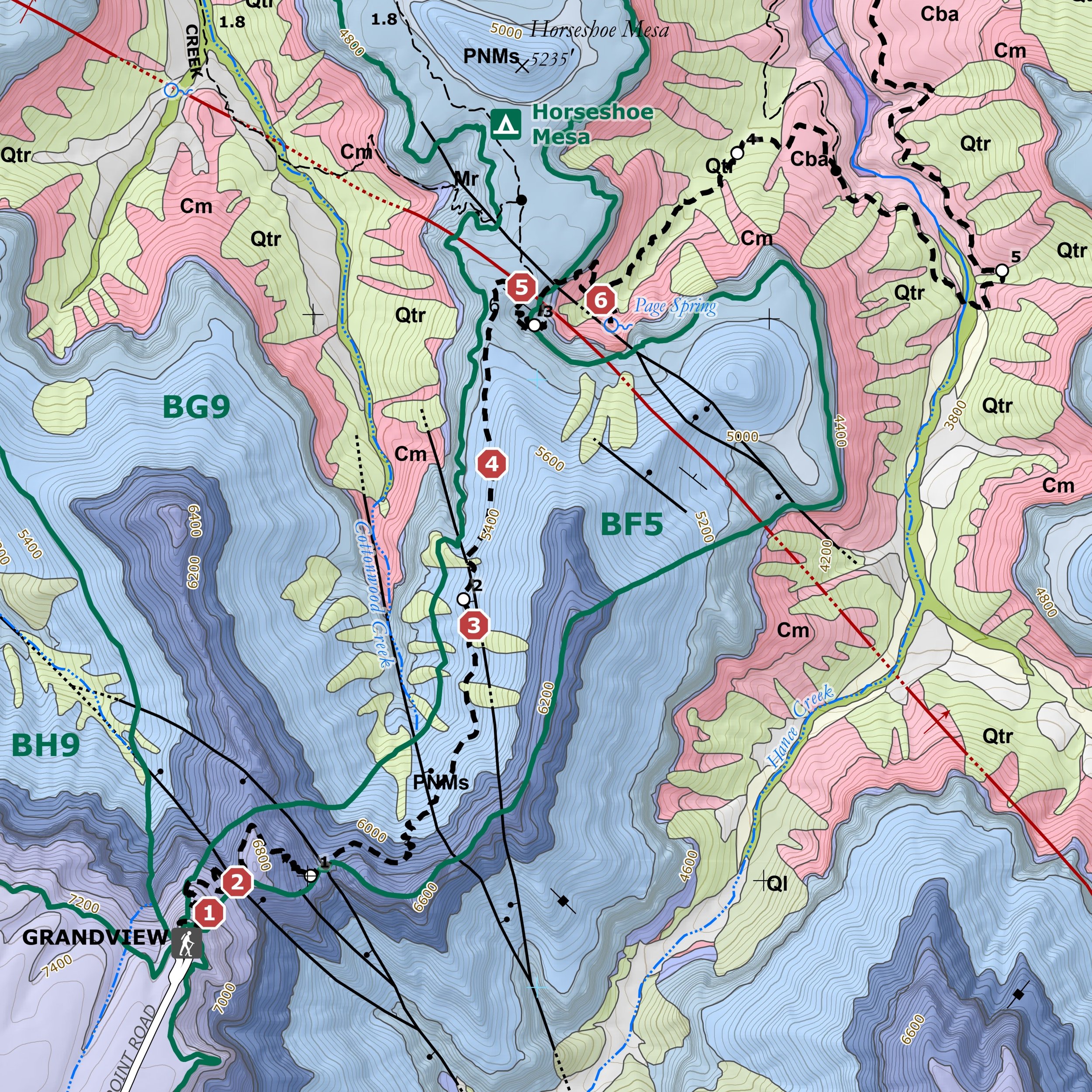
Use these maps on a hike in the Grand Canyon to know what rock units you will cross through, how key landmarks were formed, and gain a deeper understanding of Grand Canyon geology by pausing at each “Geology Stop” to observe a geologic feature of interest, such as stream piracy, ancient fossil tracks, or the Great Unconformity.
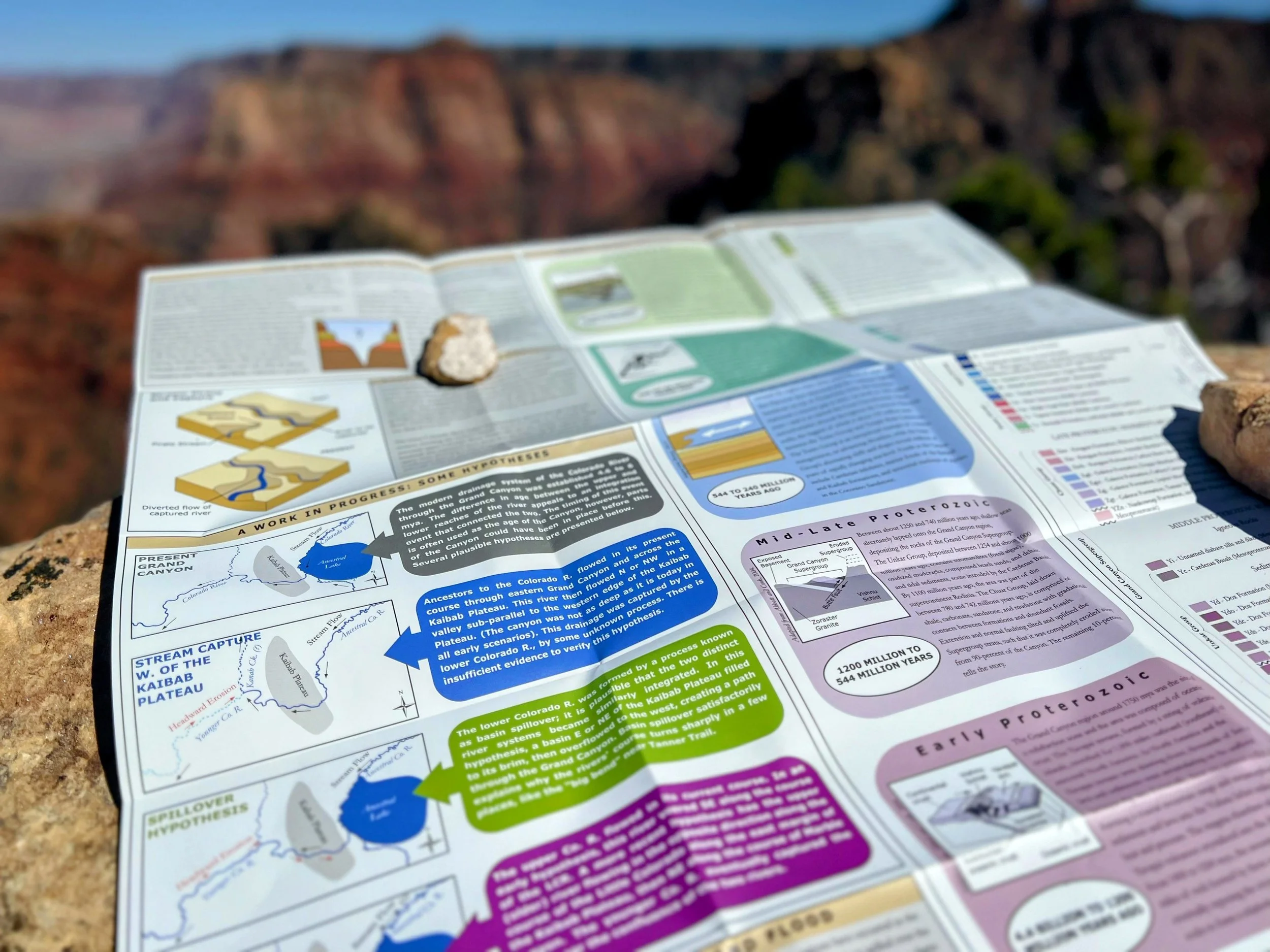
The map also contains important trail information, including elevation profile, water sources, backcountry zoning, and historical facts about the trail and the Grand Canyon. On the reverse of the map is the rock unit legend and an abundance of graphics, photos, and information about the geology of the Grand Canyon, including stratigraphic column, hypotheses regarding the formation of the Grand Canyon, the geologic eras in the Grand Canyon, the origins of the Grand Canyon’s lava flows and volcanoes, and a map of major faults.
The unfolded size is 18” x 24”, and the folded size is 6.25” x 4”.
Geologic Trail Map of the Grand Canyon: Tanner Trail. This hike features open, sweeping views very different from those of the Inner Gorge. Here, you see the river for much of the descent, and the tilted and faulted Proterozoic layers of the Grand Canyon Supergroup meet the Cambrian Tapeats Sandstone in a striking angular unconformity. A layer cake of Paleozoic rocks forms the spectacular 4,000-ft cliff of the Palisades of the Desert. The geologic drama is due to the Butte Fault, one of the most important in the Canyon, which has influenced the geography of the region for more than 1 billion years. Here it has formed the East Kaibab monocline and marks the eastern edge of the Grand Canyon and the end of Marble Canyon. This trail starts at Lipan Point (the Tanner Trailhead), and ends at Tanner Rapid, a one-way distance of 7.7 miles.
These folded pocket-sized maps are waterproof and tear-resistant and are also available as georeferenced digital maps on the Avenza Maps store.
The Geologic Trail Maps of the Grand Canyon combine the best of two worlds: geology and hiking! Part geologic guidebook, part topographic trail map, the rich geologic content provides a succinct geologic summary of the trail without the need to bring a heavy guidebook.
Use these maps on a hike in the Grand Canyon to know what rock units you will cross through, how key landmarks were formed, and gain a deeper understanding of Grand Canyon geology by pausing at each “Geology Stop” to observe a geologic feature of interest, such as stream piracy, ancient fossil tracks, or the Great Unconformity.
The map also contains important trail information, including elevation profile, water sources, backcountry zoning, and historical facts about the trail and the Grand Canyon. On the reverse of the map is the rock unit legend and an abundance of graphics, photos, and information about the geology of the Grand Canyon, including stratigraphic column, hypotheses regarding the formation of the Grand Canyon, the geologic eras in the Grand Canyon, the origins of the Grand Canyon’s lava flows and volcanoes, and a map of major faults.
The unfolded size is 18” x 24”, and the folded size is 6.25” x 4”.
Geologic Trail Map of the Grand Canyon: Tanner Trail. This hike features open, sweeping views very different from those of the Inner Gorge. Here, you see the river for much of the descent, and the tilted and faulted Proterozoic layers of the Grand Canyon Supergroup meet the Cambrian Tapeats Sandstone in a striking angular unconformity. A layer cake of Paleozoic rocks forms the spectacular 4,000-ft cliff of the Palisades of the Desert. The geologic drama is due to the Butte Fault, one of the most important in the Canyon, which has influenced the geography of the region for more than 1 billion years. Here it has formed the East Kaibab monocline and marks the eastern edge of the Grand Canyon and the end of Marble Canyon. This trail starts at Lipan Point (the Tanner Trailhead), and ends at Tanner Rapid, a one-way distance of 7.7 miles.