
Geologic Trail Map of the Grand Canyon: Grandview and East Tonto Trails
These folded pocket-sized maps are waterproof and tear-resistant and are also available as georeferenced digital maps on the Avenza Maps store.
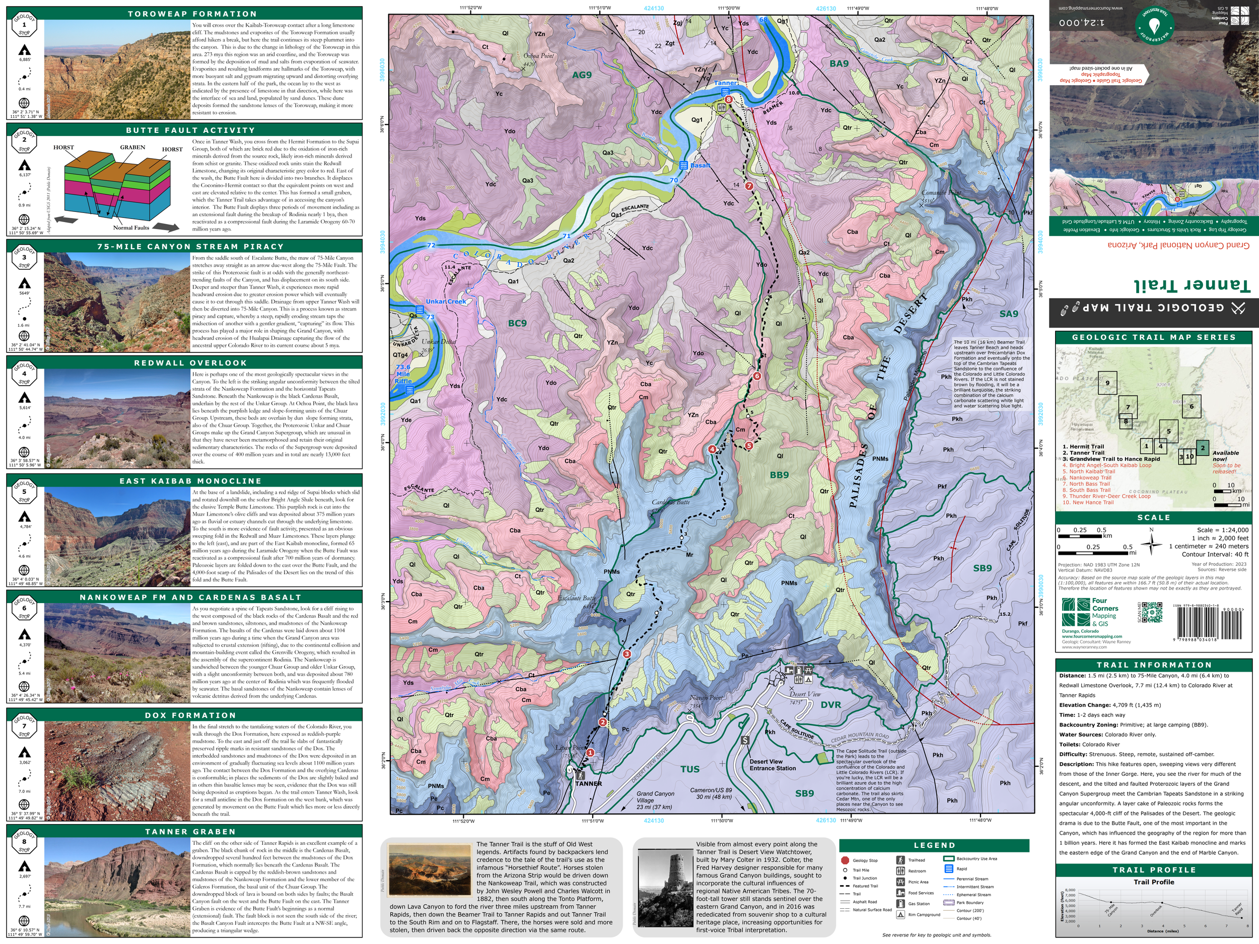
The Geologic Trail Maps of the Grand Canyon combine the best of two worlds: geology and hiking! Part geologic guidebook, part topographic trail map, the rich geologic content provides a succinct geologic summary of the trail without the need to bring a heavy guidebook.
Use these maps on a hike in the Grand Canyon to know what rock units you will cross through, how key landmarks were formed, and gain a deeper understanding of Grand Canyon geology by pausing at each “Geology Stop” to observe a geologic feature of interest, such as stream piracy, ancient fossil tracks, or the Great Unconformity.
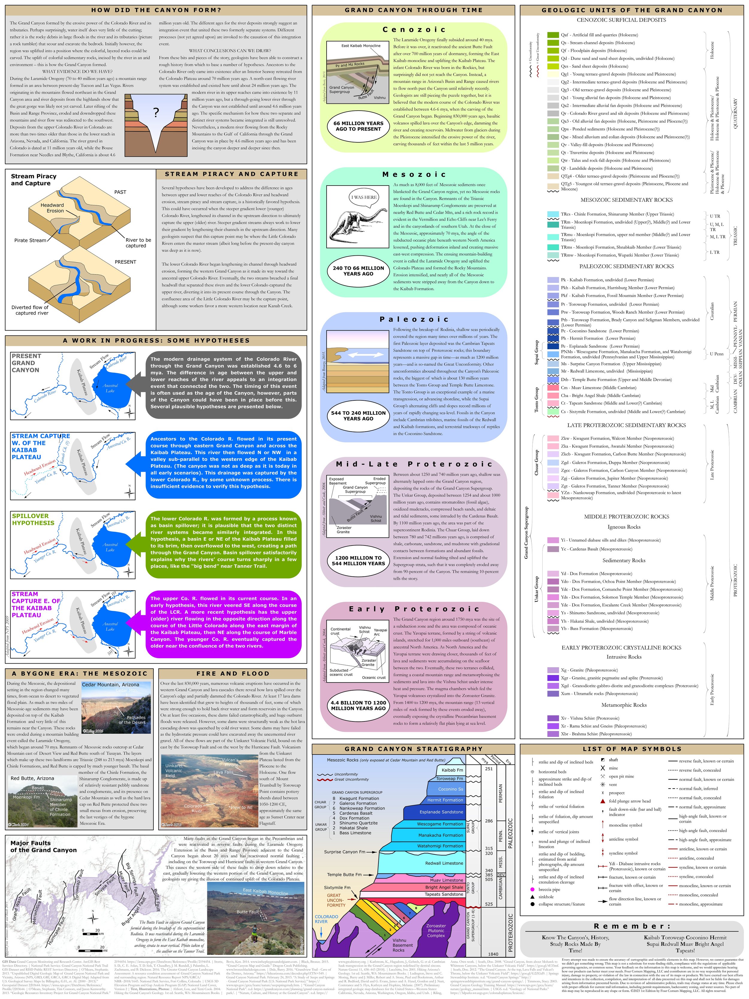
The map also contains important trail information, including elevation profile, water sources, backcountry zoning, and historical facts about the trail and the Grand Canyon. On the reverse of the map is the rock unit legend and an abundance of graphics, photos, and information about the geology of the Grand Canyon, including stratigraphic column, hypotheses regarding the formation of the Grand Canyon, the geologic eras in the Grand Canyon, the origins of the Grand Canyon’s lava flows and volcanoes, and a map of major faults.
The unfolded size is 18” x 24”, and the folded size is 6.25” x 4”.
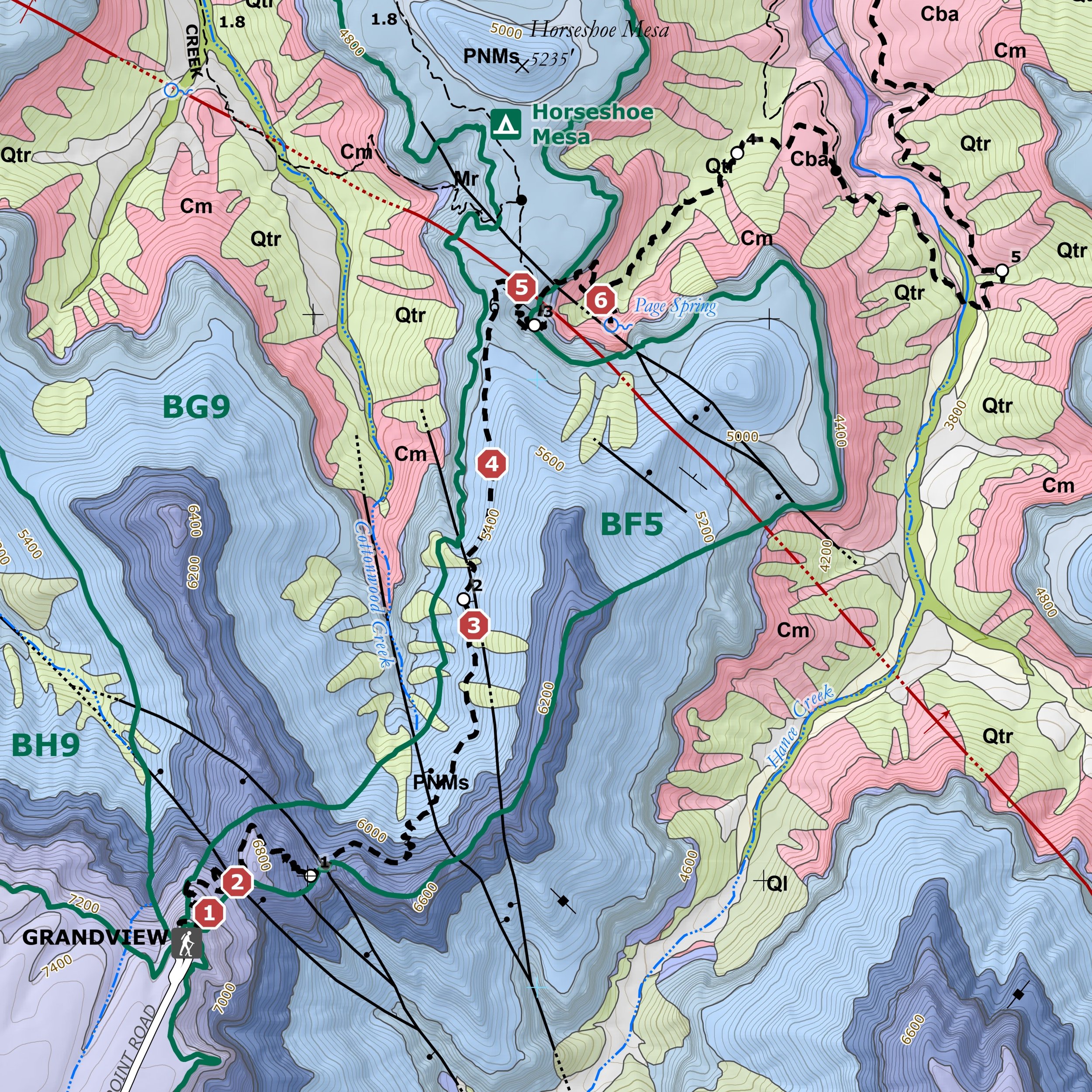
Geologic Trail Map of the Grand Canyon: Grandview and East Tonto Trails. This trail offers a glimpse into the Canyon’s mining history. Relic shafts that lie just off the trail delve into the depths of Horseshoe Mesa and the 325-million-year-old Surprise Canyon Formation. The trail to Horseshoe Mesa descends the face of the Grandview-Phantom monocline, formed during the region’s last major mountain-building episode. Witness the start of the Granite Gorge, where the 1.75-million-year-old Vishnu Schist is juxtaposed against the 1.25-million-year-old basal member of the Grand Canyon Supergroup. This trail starts at the Grandview Trailhead and ends at Hance Rapid, a one-way distance of 11.1 miles.
These folded pocket-sized maps are waterproof and tear-resistant and are also available as georeferenced digital maps on the Avenza Maps store.
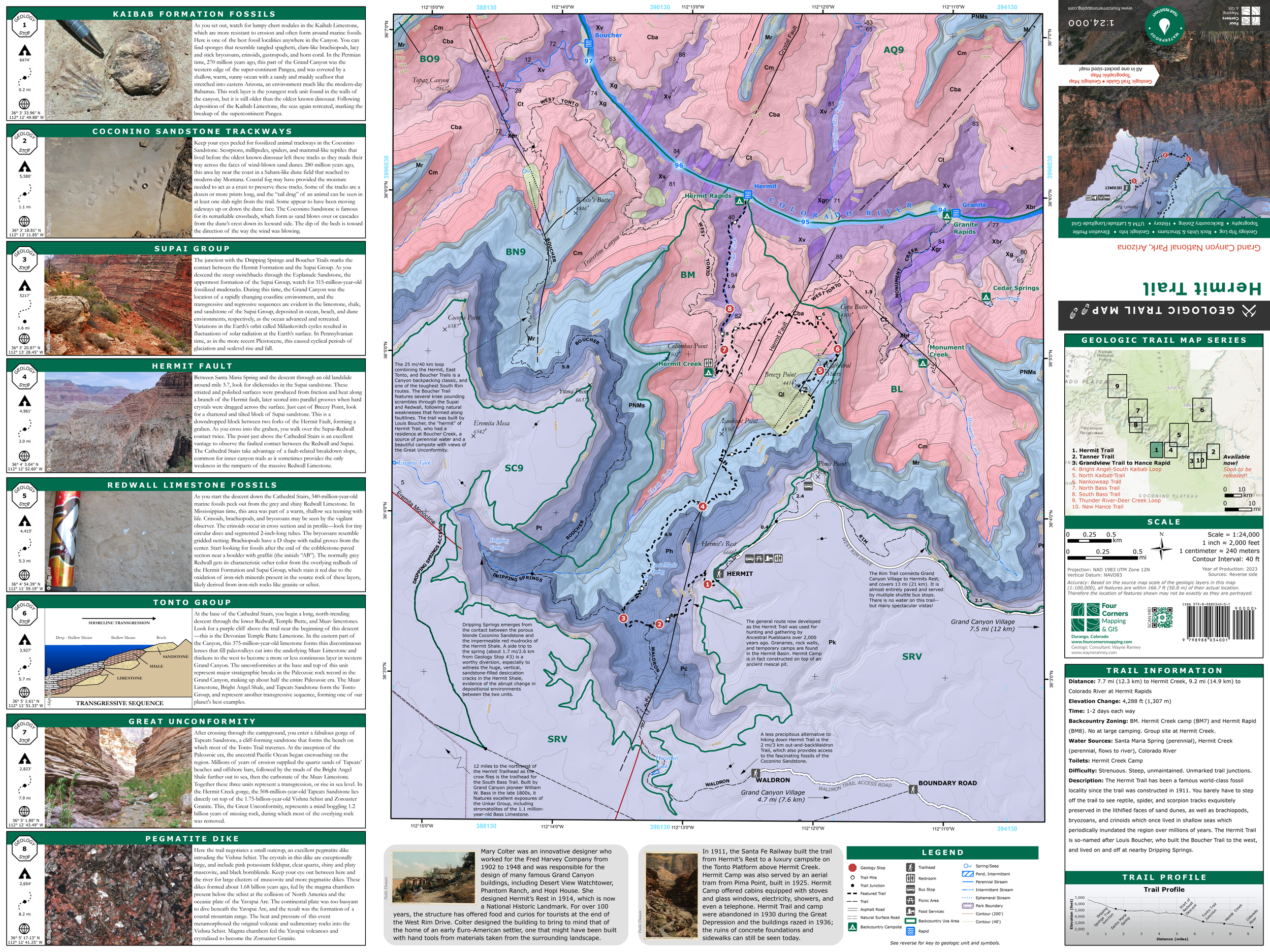
The Geologic Trail Maps of the Grand Canyon combine the best of two worlds: geology and hiking! Part geologic guidebook, part topographic trail map, the rich geologic content provides a succinct geologic summary of the trail without the need to bring a heavy guidebook.
Use these maps on a hike in the Grand Canyon to know what rock units you will cross through, how key landmarks were formed, and gain a deeper understanding of Grand Canyon geology by pausing at each “Geology Stop” to observe a geologic feature of interest, such as stream piracy, ancient fossil tracks, or the Great Unconformity.
The map also contains important trail information, including elevation profile, water sources, backcountry zoning, and historical facts about the trail and the Grand Canyon. On the reverse of the map is the rock unit legend and an abundance of graphics, photos, and information about the geology of the Grand Canyon, including stratigraphic column, hypotheses regarding the formation of the Grand Canyon, the geologic eras in the Grand Canyon, the origins of the Grand Canyon’s lava flows and volcanoes, and a map of major faults.
The unfolded size is 18” x 24”, and the folded size is 6.25” x 4”.
Geologic Trail Map of the Grand Canyon: Grandview and East Tonto Trails. This trail offers a glimpse into the Canyon’s mining history. Relic shafts that lie just off the trail delve into the depths of Horseshoe Mesa and the 325-million-year-old Surprise Canyon Formation. The trail to Horseshoe Mesa descends the face of the Grandview-Phantom monocline, formed during the region’s last major mountain-building episode. Witness the start of the Granite Gorge, where the 1.75-million-year-old Vishnu Schist is juxtaposed against the 1.25-million-year-old basal member of the Grand Canyon Supergroup. This trail starts at the Grandview Trailhead and ends at Hance Rapid, a one-way distance of 11.1 miles.
These folded pocket-sized maps are waterproof and tear-resistant and are also available as georeferenced digital maps on the Avenza Maps store.
The Geologic Trail Maps of the Grand Canyon combine the best of two worlds: geology and hiking! Part geologic guidebook, part topographic trail map, the rich geologic content provides a succinct geologic summary of the trail without the need to bring a heavy guidebook.
Use these maps on a hike in the Grand Canyon to know what rock units you will cross through, how key landmarks were formed, and gain a deeper understanding of Grand Canyon geology by pausing at each “Geology Stop” to observe a geologic feature of interest, such as stream piracy, ancient fossil tracks, or the Great Unconformity.
The map also contains important trail information, including elevation profile, water sources, backcountry zoning, and historical facts about the trail and the Grand Canyon. On the reverse of the map is the rock unit legend and an abundance of graphics, photos, and information about the geology of the Grand Canyon, including stratigraphic column, hypotheses regarding the formation of the Grand Canyon, the geologic eras in the Grand Canyon, the origins of the Grand Canyon’s lava flows and volcanoes, and a map of major faults.
The unfolded size is 18” x 24”, and the folded size is 6.25” x 4”.
Geologic Trail Map of the Grand Canyon: Grandview and East Tonto Trails. This trail offers a glimpse into the Canyon’s mining history. Relic shafts that lie just off the trail delve into the depths of Horseshoe Mesa and the 325-million-year-old Surprise Canyon Formation. The trail to Horseshoe Mesa descends the face of the Grandview-Phantom monocline, formed during the region’s last major mountain-building episode. Witness the start of the Granite Gorge, where the 1.75-million-year-old Vishnu Schist is juxtaposed against the 1.25-million-year-old basal member of the Grand Canyon Supergroup. This trail starts at the Grandview Trailhead and ends at Hance Rapid, a one-way distance of 11.1 miles.