
Geologic Trail Map of the Grand Canyon: Hermit Trail
These folded pocket-sized maps are waterproof and tear-resistant and are also available as georeferenced digital maps on the Avenza Maps store.
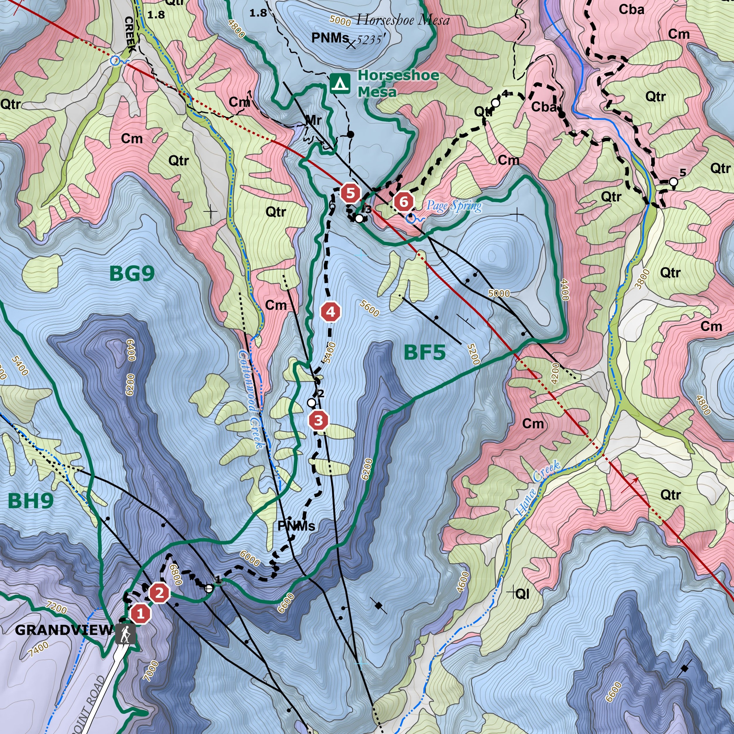
The Geologic Trail Maps of the Grand Canyon combine the best of two worlds: geology and hiking! Part geologic guidebook, part topographic trail map, the rich geologic content provides a succinct geologic summary of the trail without the need to bring a heavy guidebook.
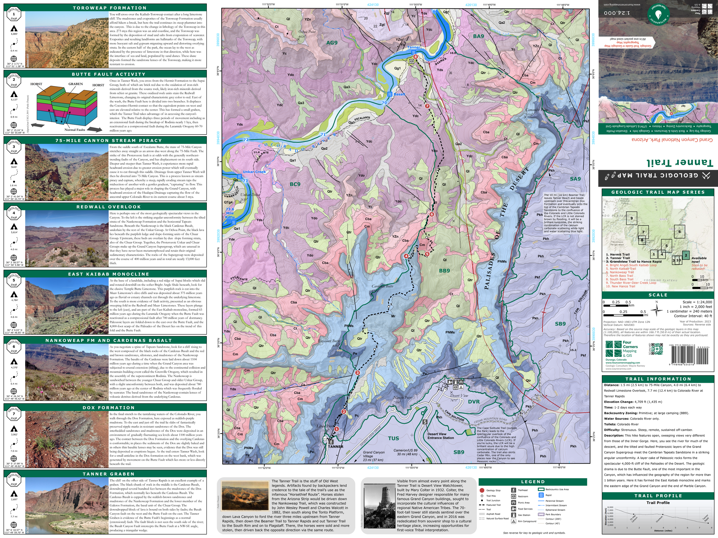
Use these maps on a hike in the Grand Canyon to know what rock units you will cross through, how key landmarks were formed, and gain a deeper understanding of Grand Canyon geology by pausing at each “Geology Stop” to observe a geologic feature of interest, such as stream piracy, ancient fossil tracks, or the Great Unconformity.
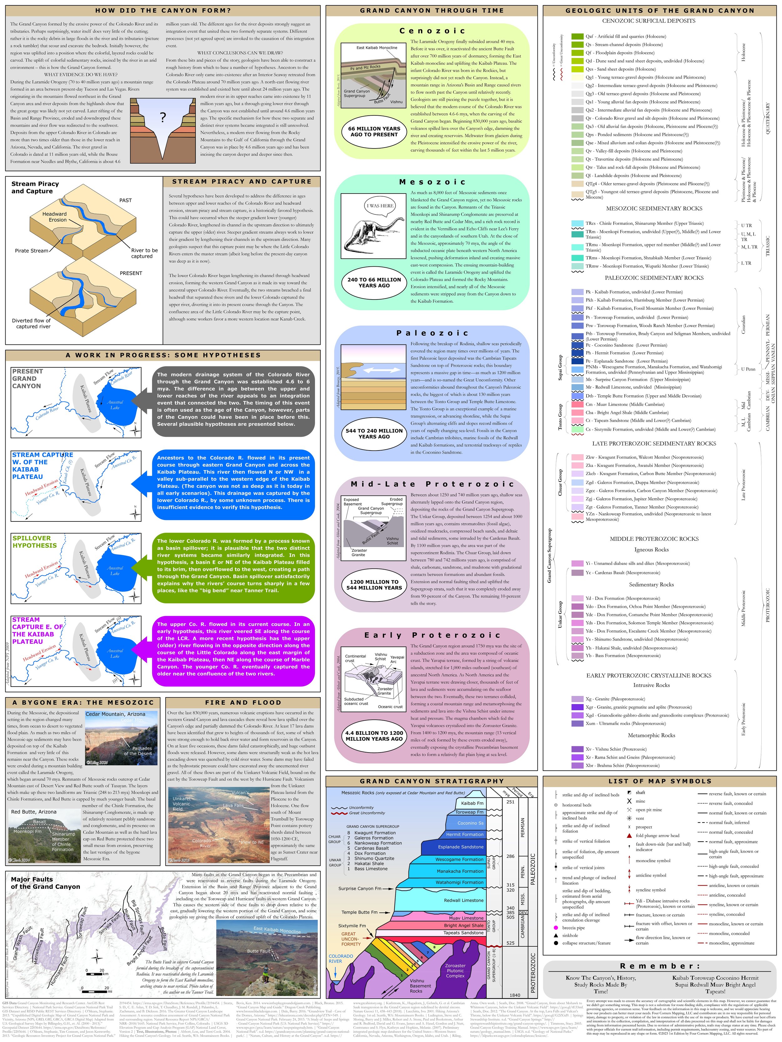
The map also contains important trail information, including elevation profile, water sources, backcountry zoning, and historical facts about the trail and the Grand Canyon. On the reverse of the map is the rock unit legend and an abundance of graphics, photos, and information about the geology of the Grand Canyon, including stratigraphic column, hypotheses regarding the formation of the Grand Canyon, the geologic eras in the Grand Canyon, the origins of the Grand Canyon’s lava flows and volcanoes, and a map of major faults.
The unfolded size is 18” x 24”, and the folded size is 6.25” x 4”.
Geologic Trail Map of the Grand Canyon: Hermit Trail. The Hermit Trail has been a famous world-class fossil locality since the trail was constructed in 1911. You barely have to step off the trail to see reptile, spider, and scorpion tracks exquisitely preserved in the lithified faces of sand dunes, as well as brachiopods, bryozoans, and crinoids which once lived in shallow seas which periodically inundated the region over millions of years. The Hermit Trail is so named after Louis Boucher, who built the Boucher Trail to the west, and lived on and off at nearby Dripping Springs. This trail starts at Hermit’s Rest (the Hermit Trailhead), and ends at Hermit Rapid, a one-way distance of 9.2 miles.
These folded pocket-sized maps are waterproof and tear-resistant and are also available as georeferenced digital maps on the Avenza Maps store.
The Geologic Trail Maps of the Grand Canyon combine the best of two worlds: geology and hiking! Part geologic guidebook, part topographic trail map, the rich geologic content provides a succinct geologic summary of the trail without the need to bring a heavy guidebook.
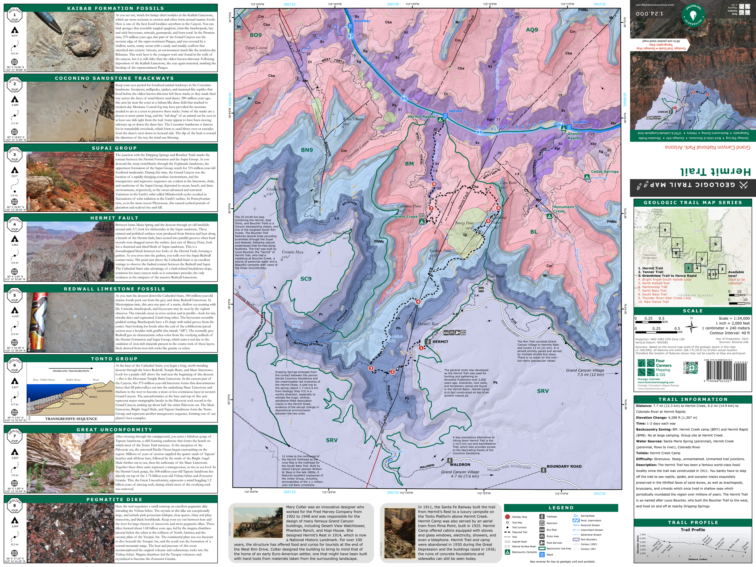
Use these maps on a hike in the Grand Canyon to know what rock units you will cross through, how key landmarks were formed, and gain a deeper understanding of Grand Canyon geology by pausing at each “Geology Stop” to observe a geologic feature of interest, such as stream piracy, ancient fossil tracks, or the Great Unconformity.
The map also contains important trail information, including elevation profile, water sources, backcountry zoning, and historical facts about the trail and the Grand Canyon. On the reverse of the map is the rock unit legend and an abundance of graphics, photos, and information about the geology of the Grand Canyon, including stratigraphic column, hypotheses regarding the formation of the Grand Canyon, the geologic eras in the Grand Canyon, the origins of the Grand Canyon’s lava flows and volcanoes, and a map of major faults.
The unfolded size is 18” x 24”, and the folded size is 6.25” x 4”.
Geologic Trail Map of the Grand Canyon: Hermit Trail. The Hermit Trail has been a famous world-class fossil locality since the trail was constructed in 1911. You barely have to step off the trail to see reptile, spider, and scorpion tracks exquisitely preserved in the lithified faces of sand dunes, as well as brachiopods, bryozoans, and crinoids which once lived in shallow seas which periodically inundated the region over millions of years. The Hermit Trail is so named after Louis Boucher, who built the Boucher Trail to the west, and lived on and off at nearby Dripping Springs. This trail starts at Hermit’s Rest (the Hermit Trailhead), and ends at Hermit Rapid, a one-way distance of 9.2 miles.
These folded pocket-sized maps are waterproof and tear-resistant and are also available as georeferenced digital maps on the Avenza Maps store.
The Geologic Trail Maps of the Grand Canyon combine the best of two worlds: geology and hiking! Part geologic guidebook, part topographic trail map, the rich geologic content provides a succinct geologic summary of the trail without the need to bring a heavy guidebook.
Use these maps on a hike in the Grand Canyon to know what rock units you will cross through, how key landmarks were formed, and gain a deeper understanding of Grand Canyon geology by pausing at each “Geology Stop” to observe a geologic feature of interest, such as stream piracy, ancient fossil tracks, or the Great Unconformity.
The map also contains important trail information, including elevation profile, water sources, backcountry zoning, and historical facts about the trail and the Grand Canyon. On the reverse of the map is the rock unit legend and an abundance of graphics, photos, and information about the geology of the Grand Canyon, including stratigraphic column, hypotheses regarding the formation of the Grand Canyon, the geologic eras in the Grand Canyon, the origins of the Grand Canyon’s lava flows and volcanoes, and a map of major faults.
The unfolded size is 18” x 24”, and the folded size is 6.25” x 4”.
Geologic Trail Map of the Grand Canyon: Hermit Trail. The Hermit Trail has been a famous world-class fossil locality since the trail was constructed in 1911. You barely have to step off the trail to see reptile, spider, and scorpion tracks exquisitely preserved in the lithified faces of sand dunes, as well as brachiopods, bryozoans, and crinoids which once lived in shallow seas which periodically inundated the region over millions of years. The Hermit Trail is so named after Louis Boucher, who built the Boucher Trail to the west, and lived on and off at nearby Dripping Springs. This trail starts at Hermit’s Rest (the Hermit Trailhead), and ends at Hermit Rapid, a one-way distance of 9.2 miles.