

Cartography
We produce custom cartography for print, web, and wall.

The Diné-led non-profit Tó Nizhóní Ání entrusted me to make this map of Black Mesa (Dził Yíjiin)—a vast, sloping plateau that rises over 3,000 feet from the Little Colorado River, deep in the heart of the Navajo and Hopi Reservations in northeastern Arizona. Tó Nizhóní Ání, or "Sacred Water Speaks", has long worked to protect Black Mesa's water sources from industrial use and waste, leading the effort to stop Peabody Coal from using the Navajo Aquifer—the only source of potable groundwater in the region. This map helps tell the story of those threats and the ongoing efforts to safeguard water in this beautiful high desert landscape. As this project unfolded, it became clear that the documentation of wells and springs on Black Mesa is fragmented and incomplete. Historical windmills shown on pre-mine topographic maps and springs recalled by elders are missing from modern records. The challenge of simply navigating the disconnected network of dirt roads likely contributes to this gap. Without an accurate well record, the challenge of fighting for water rights increases exponentially. It is essential that all water sources are correctly cataloged, including the historical ones that have slipped through the cracks. For Tó Nizhóní Ání, this map is more than just a reference—it's an invaluable resource for Black Mesa residents, helping them navigate the region's remote roads, visualize interconnected water systems, and advocate for their rightful access to water. Learn more: https://tonizhoniani.org

The Geologic Trail Map series presents a rock-centric view of popular Grand Canyon trails, combining a trail map with a geologic guidebook. This map turns the trail into a geologic trip log, pointing out juicy tidbits of geology as you hike, from fossilized spider tracks to the Great Unconformity. There is also a ton of information about the geologic history of the Grand Canyon, with infographics and visuals that answer questions like “Why are there no dinosaurs in the Canyon?” and “How was the Canyon formed?” Now anyone can be prepared to dole out unsolicited lithologic lessons to unsuspecting passersby! Click on the image to browse the maps and purchase from the store!

Hot off the press! The the 2025 Discover Gilbert Travel Guide features several of my maps! The Town of Gilbert, Arizona started as a hay-shipping nexus and is now one of Arizona's hippest travel destinations. This was a fun project with a wild color palette and super fancy fonts. I think my favorite map is the Spring Training stadiums that's shaped like a baseball diamond! One of my favorite features of a map in the works is a reference grid of tapered crosses (purple!) that uses the existing checkerboard-like street network, which follow section lines originally surveyed in the 1860s.

This map and an accompanying large format poster were produced for the Southwestern Water Conservation District (SWCD) to illustrate watersheds and water resources within the San Juan and Dolores River Basins. The SWCD has a statutory authority to protect, conserve, use, and develop the water resources of these basins for the welfare of all the inhabitants, and safeguard for Colorado all waters to which the state is entitled.

Excited to share my contribution to a significant achievement for water conservation in Southwest Colorado! I produced detailed maps for the successful $25.6M grant proposal awarded January 2025 to the Southwestern Water Conservation District by the Bureau of Reclamation's Upper Colorado River Basin Environmental Drought Mitigation Program. This funding will support 17 critical projects in the Dolores and San Juan River Basins, advancing drought resiliency through wetland and fen restoration, invasive species removal, fish passage and habitat connectivity, and more. The maps helped visualize and communicate the scope and scale of these projects and the successful contribution of restoration efforts to mitigate the effects of drought. Collaboration and innovation are key in securing meaningful environmental funding, and I'm honored that my cartographic contribution helped to support this impactful initiative.

To conserve outstanding ecological, cultural, historical, and recreational resources surrounding the Dolores River in western Colorado, a new national monument has been proposed on public lands. To help answer questions about the draft proposed boundary and what resources are located in and around it, Four Corners Mapping & GIS was commissioned to create this map. Regardless of monument support or opposition, this map is intended to provide a point of reference and aid in discussions for all involved in the process.

I had less than a day to design this and two other maps for emergency public outreach efforts to help inform area residents and stakeholders about proposed development in the Amargosa River Basin, Nevada, an area of extraordinary biodiversity, with the highest concentration of endemic species of any single subbasin in the country. What's at stake? Development of lands with important desert tortoise habitat, right up to peoples' homes and property, as well as the Ash Meadows National Wildlife Refuge and Big Dune Area of Critical Environmental Concern. Produced for the Center of Biological Diversity and the Amargosa Conservancy, October 2024.

In 2023, the City of Durango published a major update to its Multimodal Plan, which guides the implementation of a multimodal transportation network. Four Corners Mapping produced all the maps for the plan, including Transit Network, Crashes Involving Bikes and Pedestrians, Affordable Housing, Bike and Pedestrian Networks, and more.

This San Luis Valley Wetlands 101 Factsheet and map was developed for the Rio Grande Basin Roundtable as part of its "101 Fact Sheet" series, a public education effort to identify and explain the unique resources of the San Luis Valley in southcentral Colorado.

Everyone loves a treasure hunt! I made this map for an event hosted by a local artist collective, the Animas City Night Bazaar. The theme for the night was "River Pirates", and the event featured pirate-themed games, music, and activities, including a real treasure hunt using this map! Participants got the map as a scroll tied with red thread, then used it to find and decode the secret message on each of four clues using the cipher on the neatline to find the “key” to unlock the treasure chest. The key’s final clue asked them to tell their favorite pirate joke, and then they could pick out a treasure. This map was a joy to produce, and brought out the kid in everyone!

This map was created for the feature article "Drops of Hope Along the Colorado River" by Morgan Sjogren, published in the Summer 2023 issue of Sierra Magazine, the magazine of the Sierra Club.

This large format hard copy map was produced for the Wilderness Society and was part of a map series covering the nation highlighting Department of Defense installations, special use airspace, surface ownership, and protected environmental conservation areas. The series included extents covering the midwest, south, northeast, and western United States; a separate series was produced for each of the 50 states, Puerto Rico, and Washington DC.

This map was part of a series produced for the Wilderness Society (TWS) to accompany an Objects Assessment report of the Camp Hale, Colorado area composed by TWS staff. The report was used in the TWS campaign to promote the region's designation as a National Monument. In October 2022, President Biden signed a proclamation establishing the Camp Hale – Continental Divide National Monument.

This was part of a series of figures produced for an exhibit for Western Resource Advocates (WRA) to support a presentation during the Colorado Oil and Gas Conservation Commission Financial Assurance Rulemaking Hearing on November 10, 2021. This figure displays the number of oil and gas wells in Colorado in High Priority Habitat and Disproportionately Impacted Communities to highlight the importance of bonding to ensure reclamation. Clicking the link will take you to WRA's six-minute presentation at the hearing on YouTube.

We took a deep dive into Glen Canyon for the artwork and cartography for Morgan Sjogren's piece, "A Once and Future Canyon", in Issue 17 of The Gulch Magazine. Available online and in print.

Interactive web map used in a Story Map for Western Resource Advocates to support their campaign against the Lake Powell Pipeline

Map produced for the American Alpine Club Journal for the story "Exploring the Yarkhun", 2020.
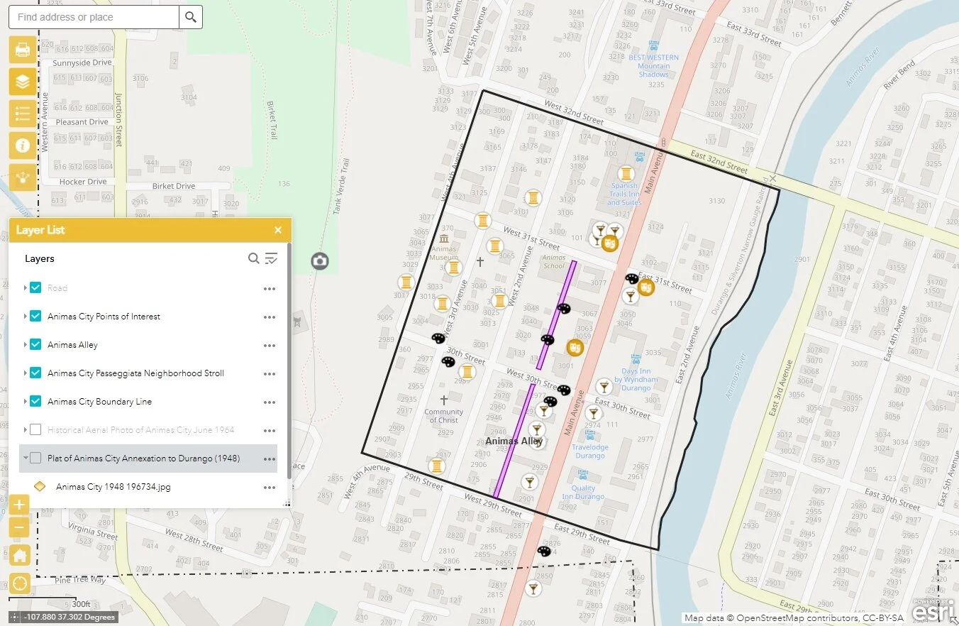
Mobile Map App for the Animas City Night Bazaar, 2020.

Map produced for The Gulch Magazine for the story "Walls" about the border wall and its effect on the jaguar, an endangered species and frequent border crosser.

Map produced for the American Alpine Club Journal for the story "Recon: Nepal's Wild, Wild West", 2020.
